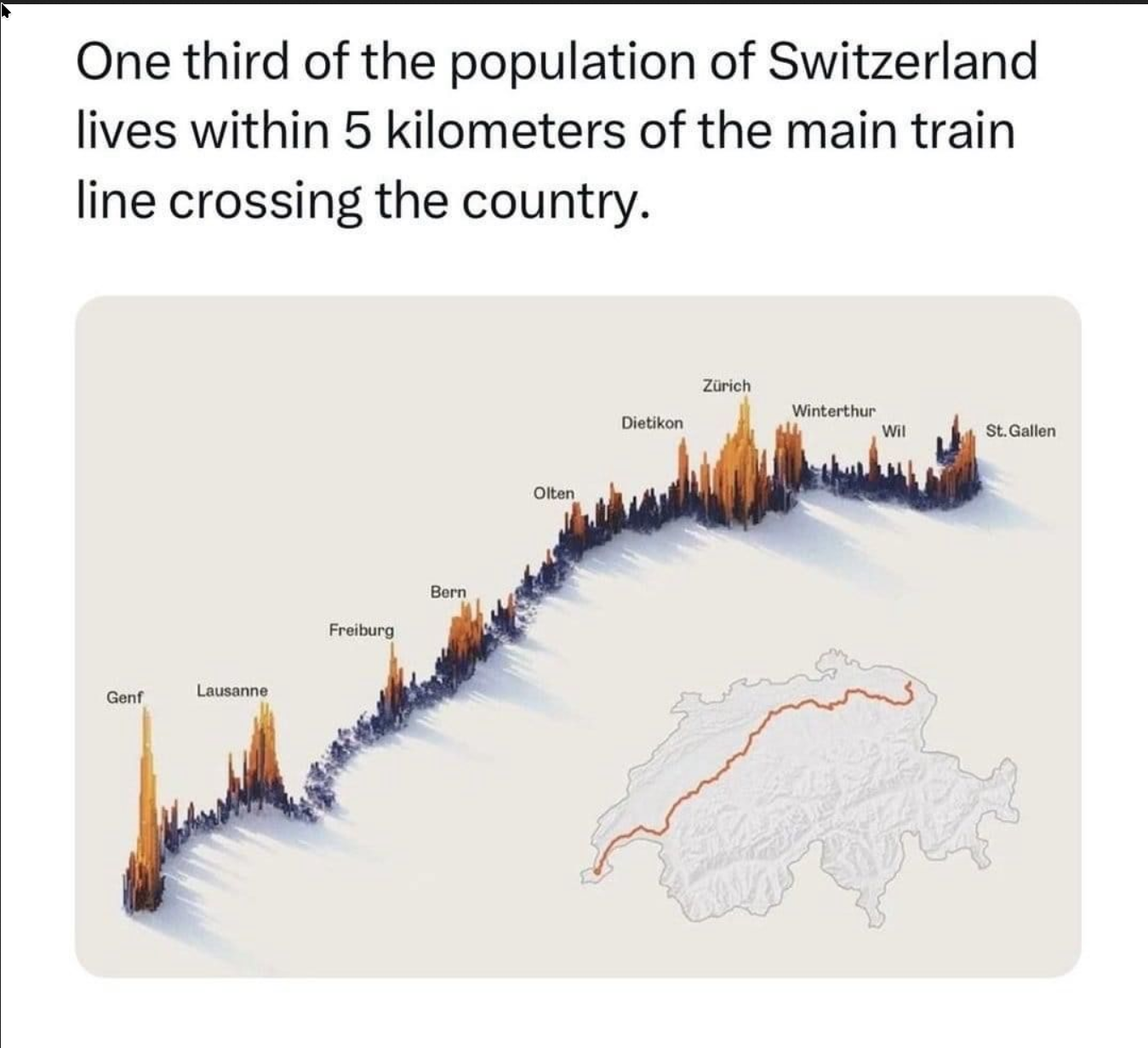
this post was submitted on 26 Jun 2024
272 points (97.6% liked)

Data is Beautiful

619 readers
72 users here now

Be respectful

founded 3 weeks ago
MODERATORS
all 27 comments
sorted by: hot top controversial new old
[–] OmegaMouse@pawb.social 58 points 2 weeks ago (3 children)

Isn't this statement kinda backwards though? Surely the big cities developed along that line due to the natural geography (flat land, near bodies of water and with protection from the mountains) and then once trains first came along, it made sense to connect those cities. It's not that people happen to live within 5km of the trainline, but that the trainline was built there because that's where people lived.

[–] Blaze@reddthat.com 11 points 2 weeks ago (7 children)

I see where you come from, but I guess it's still uncommon to have a third of a country living on a line

Also, the data looks quite good, which is the main objective of this community

[–] OmegaMouse@pawb.social 18 points 2 weeks ago

Yeah it's pretty data for sure. Just the conclusion that has been drawn from it is a bit odd! Correlation/causation etc etc

[–] mojofrododojo@lemmy.world 4 points 2 weeks ago

but I guess it’s still uncommon to have a third of a country living on a line

mmm... no, it's exactly what you'd expect in a country chock fulla mountains. terrain dictates where roads, rails AND TOWNS grow.

[–] Dkarma@lemmy.world 4 points 2 weeks ago

They have to...lol. There's no other way to travel efficiently.

[–] akilou@sh.itjust.works 3 points 2 weeks ago

Canada

Chile

[–] sunzu@kbin.run 2 points 2 weeks ago (3 children)

I bet US can get something similar for NE corridor

[–] lengau@midwest.social 3 points 2 weeks ago

Not as big a portion of the country, but yeah coastal areas will often have a large population living in roughly a line.

In North America I believe the line connecting the most people would go from Quebec City through Montreal, Ottawa, Toronto, London, Detroit, Chicago, Milwaukee and Minneapolis (though maybe not within just 5 km of it). This is the most populous part of the Great Lakes Megalopolis and into the St. Lawrence.

[–] StaticFalconar@lemmy.world 3 points 2 weeks ago (1 children)

Switzerland is about as big as Vermont and New Hampshire.

[–] sunzu@kbin.run 2 points 2 weeks ago (1 children)

NE corridor is 100m people

[–] Swedneck@discuss.tchncs.de 2 points 1 week ago

for real, more people live in new york alone than do in finland

[–] Blaze@reddthat.com 1 points 2 weeks ago

Could be, feel free to post a similar study on that region if you find one!

[–] acockworkorange@mander.xyz 1 points 2 weeks ago

I believe something like 80% of the population of Brazil live within 50 km of the coast.

[–] jaybone@lemmy.world 1 points 2 weeks ago

Given the size and geography of the country, one might expect this.

[–] fartsparkles@sh.itjust.works 2 points 1 week ago

You’re absolutely right. That train runs across the Swiss Plateau with mountains either side of the plateau. Historically, if you were going to grow any produce, that was where you would grow it so it’s no surprise there’s such a density of people in the flatter part of an extremely mountainous country.

[–] telllos@lemmy.world 0 points 2 weeks ago

But train lines develops cities. I know that when a train line that connects big cities extends to smaller town they boom.

[–] Infynis@midwest.social 18 points 2 weeks ago (2 children)

Doesn't that just mean that this is PeopleLiveInCities?

[–] Zipitydew@sh.itjust.works 10 points 2 weeks ago

Yeah and those cities exist in that configuration because they're where the farm land is they grew out of. There are mountains running along the northern and southern borders of the country. Most people live in the valley between.

It's like the same as wondering why much of Chicago's train system runs north/south. There's a big ass lake to the east stopping expansion that direction.

[–] Swedneck@discuss.tchncs.de 2 points 1 week ago

RailwaysRunBetweenCities

[–] Nougat@fedia.io 13 points 2 weeks ago (1 children)

100% of me lives wherever I happen to be.

[–] runeko@programming.dev 6 points 2 weeks ago

You never let your mind wander?

[–] hsdkfr734r@feddit.nl 13 points 2 weeks ago

I can still see you Mr. Mouse pointer.

[–] prime_number_314159@lemmy.world 13 points 2 weeks ago

Yet another demonstration of the inferiority of the metric system. More than 90% of the US population lives within 5 kilomiles of our largest train line.

[–] Kazumara@discuss.tchncs.de 4 points 2 weeks ago* (last edited 2 weeks ago) (2 children)

"Main train line" what is that supposed to mean exactly?

What about Lausanne-Yverdon-Neuchatel-Biel-Solothurn-Olten? What about Basel-Olten-Luzern? What about Zürich-Zug-Bellinzona-Lugano? What about Lausanne-Montreux-Martigny-Sion-Visp-Brig? What about Bern-Thun-Spiez-Visp-Brig? What about Zürich-Pfäffikon-Sargans-Lanquart-Chur?

Basically just look at this interactive map if you want a fuller picture, or at this PDF if you want to see a reduced view about the long distance lines only.

And to everyone saying: "Well obviously it follows the valley!" The Mittelland is not some valley, it's a plateau between the Alps and the Jura mountain ranges and it contains about 30% of our area. Besides, you should know about the longest railway tunnel in the world, the Gotthard Base Tunnel and about the Lötschberg Base Tunnel and about the Simplon Tunnel. The Swiss rail system doesn't give up because of some mountains in the way.

[–] Skunk@jlai.lu 3 points 2 weeks ago* (last edited 2 weeks ago)

Well, it’s probably the longest one, joining west to east, Leman to Konstanz.

It’s also the busiest intercity, mostly because of the Bern-Zurich part but still.

It is named IC1 for a reason, not IC2.

And not stopping in Olten is another big plus 🤷🏻‍♂️

[–] Fedizen@lemmy.world 3 points 2 weeks ago

this is probably similar for most valleys