this post was submitted on 30 Jun 2024
99 points (95.4% liked)
Climate - truthful information about climate, related activism and politics.
5205 readers
685 users here now
Discussion of climate, how it is changing, activism around that, the politics, and the energy systems change we need in order to stabilize things.
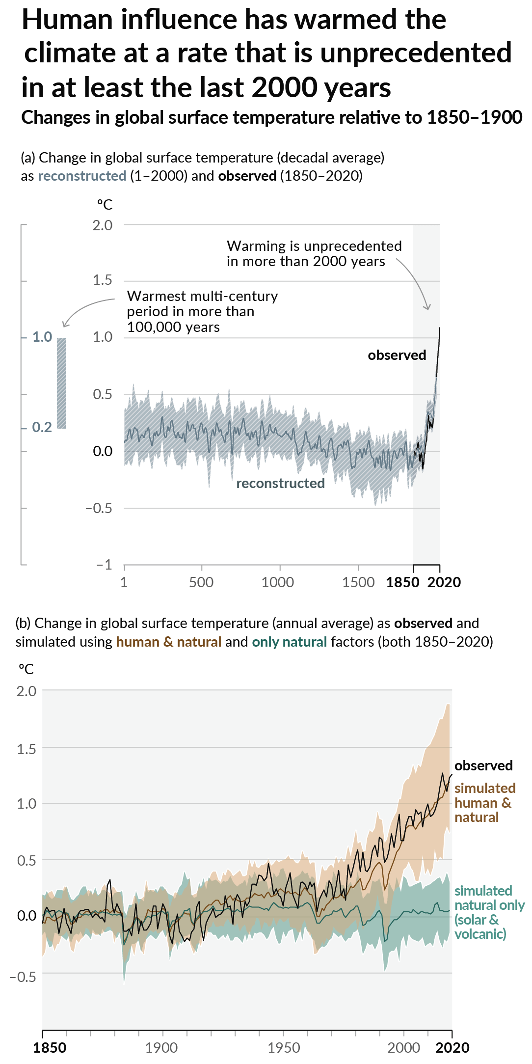
As a starting point, the burning of fossil fuels, and to a lesser extent deforestation and release of methane are responsible for the warming in recent decades:

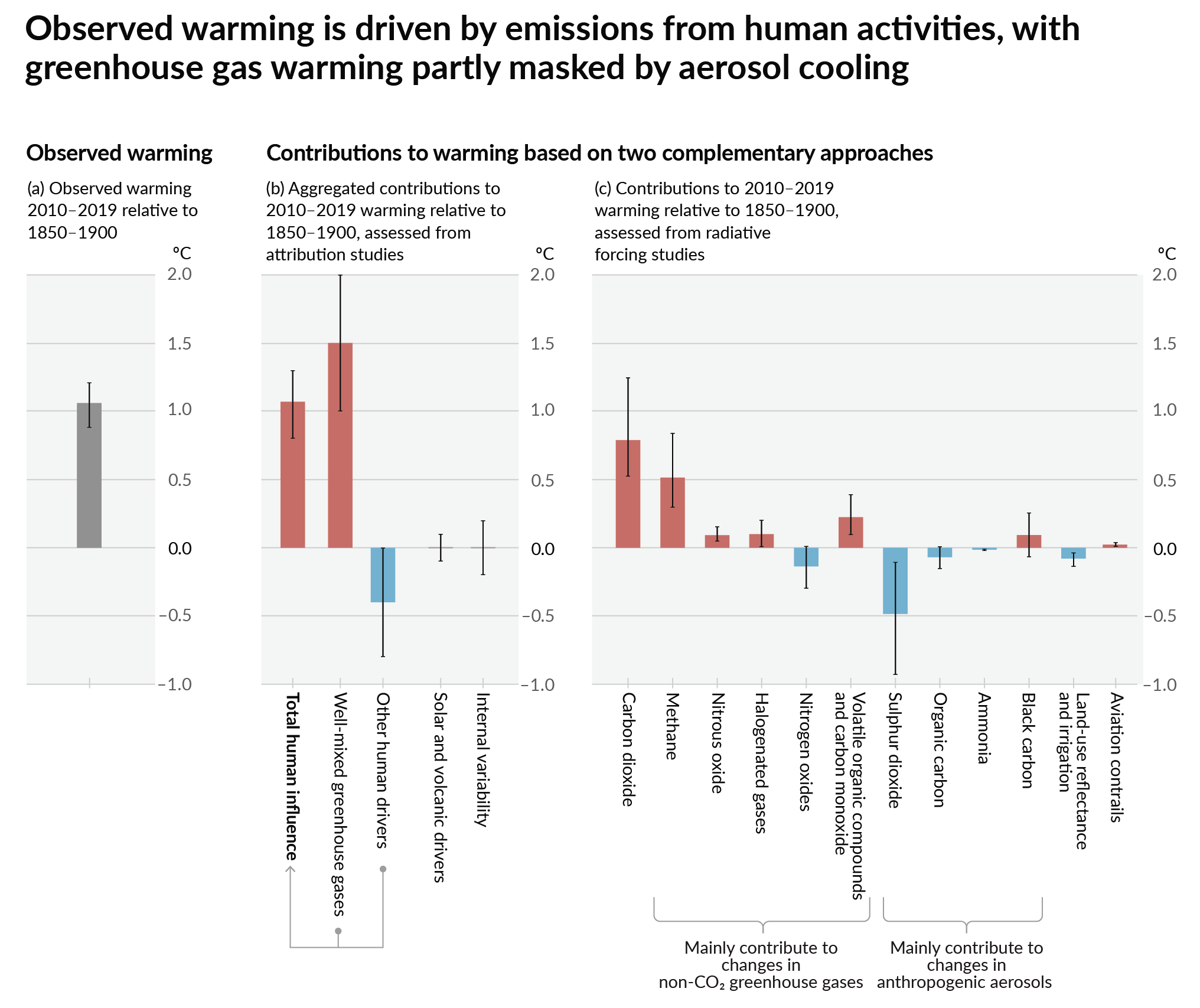
How much each change to the atmosphere has warmed the world:

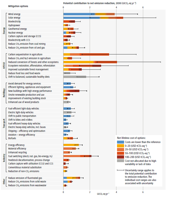
Recommended actions to cut greenhouse gas emissions in the near future:

Anti-science, inactivism, and unsupported conspiracy theories are not ok here.
founded 1 year ago
MODERATORS
you are viewing a single comment's thread
view the rest of the comments
view the rest of the comments
Non paywalled source?
Hurricane Beryl becomes Category 4 storm on its way through Caribbean
Beryl exploded into a Category 4 hurricane with maximum sustained winds of 130 mph Sunday — the earliest a storm of that intensity has been recorded in the Atlantic — leading Caribbean islands to prepare for violent storms.
The National Hurricane Center said Beryl could pose “life-threatening” problems in the Lesser Antilles, an island chain on the eastern side of the Caribbean Sea. Hurricane warnings have been issued for Barbados, St. Lucia, St. Vincent and the Grenadine Islands, Grenada and Tobago, while a tropical storm warning covers Martinique.
“All preparations should be rushed to completion today,” the Hurricane Center posted at 11 a.m. Sunday. Forecasters expect Beryl to move across the Caribbean and toward the northwestern region of the sea, affecting the Dominican Republic, Haiti, Jamaica and the Cayman Islands.
Researchers have been warning for months that the 2024 Atlantic hurricane season could be one for the record books, and now it is.
What to know about Beryl’s location and islands’ preparations
As of 1:45 p.m. Eastern time, Beryl was about 300 miles east-southeast of Barbados and was moving due west at 21 mph.
St. Lucian Prime Minister Philip J. Pierre said on Facebook that emergency service officials declared a national shutdown for the country of about 170,000 people starting at 8:30 p.m. local time Sunday.
“We need to be together and support each other as we prepare but hope and pray we are spared,” he said in a video message.
The St. Vincent and the Grenadines Meteorological Service on Sunday issued a flash-flood warning to its 100,000 residents.
At midday Sunday, Michael Tiller was looking at blue skies and calm, clear blue water from the patio of a rented vacation home in Barbados.
“You can’t really tell there’s a hurricane coming,” the Michigan resident said. “It’s a really beautiful day out here.”
Tiller plans to hunker down as soon as the winds pick up. The property managers of the home he is sharing with his family for the week came in earlier Sunday and boarded up the windows and glass doors.
He was surprised, however, that they didn’t take away the patio furniture or provide him with any other instructions.
To stay up to date and keep his family safe, Tiller is following weather updates online from a Barbados-based meteorologist, Sabu Best, who provides updates every three hours.
The family is bracing for strong winds and power outages, but Tiller isn’t too concerned.
“I’m calm and not particularly worried,” he said. “There will be adversity, but in the grander scheme of things it will be fine for us.” The family is planning to return to the United States on Wednesday.
How fast the storm strengthened
Beryl went from a tropical storm to a Category 3 hurricane in 36 hours; it intensified by 75 mph during that time frame. According to Sam Lillo, a researcher at DTN Weather, that level of rapid intensification has never happened in June and has happened only twice in July.
On Sunday morning, it reached Category 4 intensity.
What makes this so unusual
There is no precedent for a storm to intensify this quickly, nor reach this strength, in this part of the ocean during the month of June. Records date to 1851.
While flukes happen, there is a firm link between rapid intensification (the strengthening of hurricanes) and human-induced climate change. Ocean waters are running 3 or 4 degrees above average, reminiscent of August rather than June. In some cases, records are being set. It’s unsurprising that the atmosphere is responding accordingly.
Before now, the Atlantic has only ever seen two major hurricanes during June — Audrey in 1957 and Alma in 1966. “Major” hurricanes are those rated as Category 3 or higher. Both Audrey and Alma occurred in the Gulf of Mexico as early-season “homegrown” storms. The Atlantic’s Main Development Region, located between northern South America and Africa, was always believed to be inhospitable to major hurricanes during the month of June — until now.
In addition to extremely warm ocean waters, relaxed upper-level winds played a crucial role in its development. If high-altitude winds are too harsh, they can tear apart a fledgling storm. Winds are ordinarily hostile during June, but not this year.
The juxtaposition of low pressure to the northwest and a high to the north and east helped evacuate air away from Beryl in a narrow filament, “venting” it and helping it to intensify more quickly. (Imagine placing a fan at the top of a chimney — the more air you blow out the top, the more the flames will grow as air rushes in to fuel the fire at the bottom.)
Where Beryl could go next
Beryl will slam the Lesser Antilles on Monday, probably the Windward Islands, with winds of 130 mph or more. Because its strongest winds are concentrated in the center, the specific track of the storm’s eye will determine its exact impacts.
The National Hurricane Center is also expecting a storm surge of 6 to 9 feet, as well as 3 to 6 inches of rain.
High pressure to the north will act as a force field over the central Atlantic, preventing Beryl from escaping out to sea. That’s why Beryl will continue moving west.
By Tuesday, Beryl will enter the eastern Caribbean, still moving westward or slightly west-northwestward. It may be weakening acutely by then as it encounters shear, or changing winds with height, that work to knock it off-kilter.
Its eventual track in the Caribbean is unknown. Jamaica and Cuba could both be in play. So could the Yucatán Peninsula. At this point, it does look like Mexico is more likely to be hit.
There’s also a potential scenario — least likely at this point — where Beryl threads the gap between Cancún and western Cuba, entering the Gulf of Mexico. The feasibility of that scenario, and range of possible impacts, won’t be known for days.
Legend